Showing posts with label Gifford Pinchot. Show all posts

Wednesday, August 19, 2015

Panther Creek Falls

We've haven't gotten to do much camping or hiking this year. We did get to go on a one-night trip out the Panther Creek Campground. The last time we were there someone told us about Panther Creek Falls. It's up the road a little way from the campground. You really have to know it's there in order to find it. There's a gravel pit/parking area to the right of the road. From there you retrace your steps back down the road a short distance and then you have to look for the spot where the trail leads off from the road. Someone had spray-painted "FALLS," with an arrow, on the road in an attempt to help.

It's really gorgeous!! If you are ever there, be sure to stop. It's just a short walk into the woods and then you get to observation deck that looks down at the falls. 


There are some nice, smaller waterfalls near the big falls, too.

Wednesday, July 16, 2014

Paradise Creek Preview

We just got back from a really nice one-night camping trip to one of our favorite spots, Paradise Creek. It did my photographer's heart good, and I have multiple shots I'd like to share eventually, but for now I'll just post one to get started.

This is--can you guess??--Paradise Creek. :-)


Monday, September 30, 2013

Takhlakh Lake

This has been a really fun September! I have two wonderful trips that I'm very excited to tell you about. The first was a family camping trip to Takhlakh Lake. We've heard of Takhlakh Lake for years. I guess at first I was the one who really wanted to go there. Somewhere along the way, I kind of lost my enthusiasm, but Christina was still really interested in going. I'm so glad she pushed for us to finally go this year. It was probably one of the best camping spots I've ever been to. Takhlakh is a little lake at the bottom of Mt. Adams, about two hours away from our house. On still days, you can see an almost perfect reflection of the mountain in this lake. We were blessed with the very best weather you could ask for and some wonderful reflections in the lake. 

I'm not going to apologize--there are a lot of mountain pictures in this post. With every different time of day, the look of the mountain changes and I think it's all worth showing.

The afternoon that we arrived, the moon was rising right above Mt. Adams. 


Mt. Adams at sunset.

Again at sunset, from a different spot on the lake. There's some people in a canoe on the left side--I really wished we had some kayaks so we could go out on the lake!

The lake was a short walk from our camping spot. We went back to look at the mountain repeatedly each day. We also went  a couple times at night. Early in the evening the moon was out and the mountain was still reflected in the lake, but now illuminated by moonlight. Then we went back later in the night. The moon had set, but there were stars reflected in the lake--it was so beautiful! I wish I had pictures of those two views, but I don't. :-(

Sunrise--sunbeams shining over the shoulder of the mountain.

Shortly after sunrise. That ripple was created by Dad throwing a rock--it just highlights how still the rest of the water is.

Mossy trees around our campsite.


We did go on a short hike. Dad and Christina climbed on some lava rocks near the trail.

There were mushrooms everywhere!

We also saw some pikas on the rock slopes by the trail.

 Takhtakh Meadow--the trail's destination.

 One of the signs on the trail claimed that you could see Goat Rocks from the trail. We never found a spot where you could, but we did find a side trail that climbed up to a viewpoint where there was an excellent view of both Mt. Rainier and Goat Rocks.

Mt. Rainier

Goat Rocks

One more shot of Mt. Adams.

We had a great time, just relaxing out there for a couple days. The weather was a lot warmer than we had expected, which was a pleasant surprise. We even went swimming in the lake one day. Another thing that impressed me was how quiet it was up there. There's no noise pollution and not even the constant sound of a river or the ocean like we are used to at other camping spots. It was very peaceful! 

Monday, August 6, 2012

Hiking Lava Canyon

Hi there! We've had such a busy July and I haven't blogged about any of it yet! I'll try to make up for that in the next couple days here. I had a problem with uploading pictures, but I think I've found a solution. If you're a Facebook friend you'll recognize the pictures in this post. But, here I'll give more complete commentary. :-) 

So the first big event of July was a much anticipated hike to Lava Canyon, on the south side of Mt. St. Helens. We had wanted to hike this trail for several years and never gotten around to it; this was the year to complete that goal. It has some pretty interesting features that had attracted us, as you'll see below. However, until this year, the fact that some parts of the trail take you right on the edge of a steep drop-off above a fast river had escaped my notice. *gulp* Praying for safety, we went ahead with our plans to hike it with a group of friends.

I didn't take any pictures for the first half of the hike, so this picture finds us at our lunch spot and turn-around point. This is the Muddy River, which the hike follows. I know, it doesn't look very muddy, does it?


The story of Lava Canyon--as I understand it--is that the canyon was filled with mud and debris by a previous eruption of Mt. St. Helens. All of that was washed out by a lahar from the 1980 eruption. So, in a way, it's a relatively new canyon, I guess.

Having fun with some slow shutter speed.


Our lunch spot, and the bridge that marked our turn-around point.

Group shot :)
 Heading back up-river, we came to the Ship, a huge rock formation that stands in the middle of the canyon. We took a steep little side trail up to the top of the Ship and were rewarded with this view!
Looking up the valley to multiple waterfalls.
 To get onto the edge of the canyon, you have to climb a 30-40ft ladder. 

Then comes the scary part (at least, scary for me). The trail gets very narrow and takes you right past the edge of the canyon. 

Beautiful view of a waterfall, just off the edge of the trail.

Definitely out of my comfort zone.

Looking over the edge.

The final excitement on the hike was the suspension bridge. We had already crossed it earlier on the hike. We didn't actually need to cross to get back to the car, but some of us went back across just for fun. 

For me, the suspension bridge was fun, because I knew I was fairly safe, despite the view straight down to the bottom. I didn't feel so safe on the trail.

The shadow of the bridge cuts across the canyon.

The view down river.

And up the river.


Lava Canyon was definitely an exciting hike! It wasn't terribly long, but it does have some interesting features. I'm thankful for God's protection as well! It was a great time spent with friends.


Monday, September 5, 2011

Goat Rocks

We went on our last camping trip of the season this past weekend. The goal of this one was specifically to hike in Goat Rocks Wilderness, which is about 3 1/2 hours away from us. I first read about hiking Goat Rocks in the paper. I cut out the article and made it kind of a goal to get there, but it took a few years to actually do it.

We headed up to the Goat Rocks area Thursday evening and spent the night at a campground by Walupt Lake, which is not very far from the trailhead we were going to use. It was a great campground and would have been a nice place to spend a few days, especially if we had a boat or kayak.


While it would have been nice to spend more time at Walupt Lake, the main purpose for staying there was to use it as a base camp for our hike to Goat Lake the next day.  

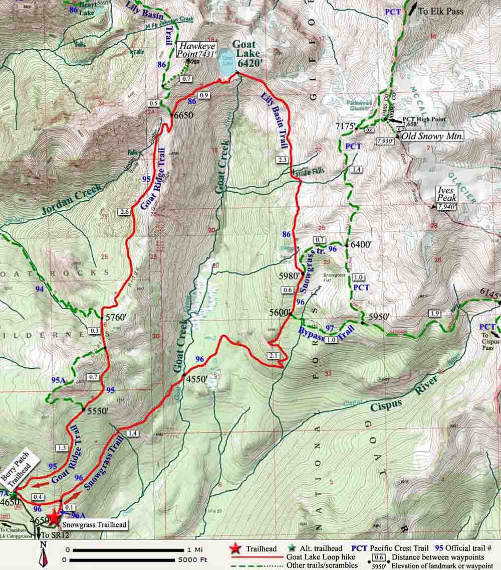
Here's a map of the 12-mile trail.


I had read really great things about this trail, so I was very excited to hike it. I was definitely not disappointed! The scenery on this hike was some of the most beautiful I've ever encountered.

The hike really got exciting once we reached the tree line and started hiking through the alpine meadows at the top of the Goat Creek Basin. The wild flowers were still in bloom, but there were a lot of snow patches that hadn't melted yet.

The narrow trail, surround by wildflowers. 

Christina heads down the trail through one of the meadows.

A shallow snow-melt pond by the trail. 

One of numerous little tributary mountain streams we had to cross.

Goat Lake is in the little bowl in the middle of these cliffs. The waterfall is where it flows out to become Goat Creek. 

Another tiny mountain stream.


Looking down the valley toward Mt. Adams.


Finally we got to Goat Lake! It was still mostly frozen over this year, as I had heard it would be. Still, it's amazing to think that on the first weekend of September, last year's snow and ice had not totally thawed.  

Dad checks out the edge of the lake.


I don't know my wildflowers very well, so I'm not sure what these are, but they were very soft to the touch.

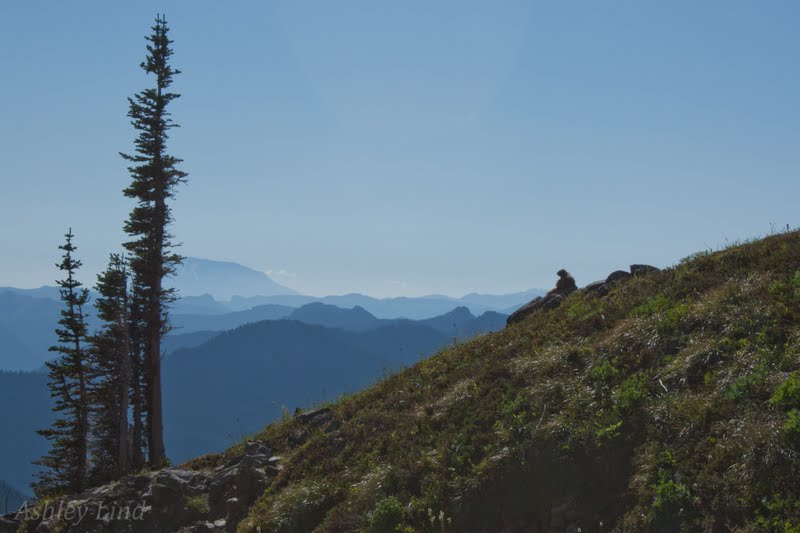
That's a marmot or something (?) on that rock, admiring the view of Mt. St. Helens.

To get back to the trailhead, we crossed Goat Ridge into Jordan Creek Basin. Here's the view down that valley toward Mt. St. Helens.

Okay, so Goat Rocks, Goat Lake, Goat Creek, Goat Ridge... there's a theme, right? You are supposed to see mountain goats in this area, but we were over halfway through the hike and we hadn't seen any. Finally, we spotted one goat high up on an opposite ridge.

It's a goat!!! (It's to the right of the two snow patches.) 

The hike made for a long and very tiring day, but it was completely worth it! I'm so thankful for God's kindness in allowing us to visit this gorgeous, wild area, and for his protection on the trail and the road.